|
Fact Sheet: _DTED
to STF Converter
|
Quick Scroll To:
DESCRIPTION
This free tool converts National Geospatial-Intelligence
Agency (NGA) Digital Terrain Elevation Data (DTED) elevation, ArcInfo ASCII
Grid, and U.S. Geological Survey (USGS) DEM ASCII data into SEDRIS Transmittal Format (STF).
NOTE: For a complete description of the DTED specification,
please refer to MIL-PRF
89020B, which can be found at the NGA
web site.
RELEASE INFORMATION
The current release version of this application is
3.1.2.3. This tool is SEDRIS 3.1.2 compliant. If you want the 4.0.0 version of this tool, please refer to the GRIDS Converter.
The application is linked statically, and additional
documentation is included in the download. You do not need to download
or install the SEDRIS SDK to use this tool.
FEATURES
This release of the DTED to STF Converter application,
which is compatible with SEDRIS SDK 3.1.x, has the following features:
- Processes all levels of DTED.
- Processes multiple-levels of DTED in one STF.
- Represents accuracy records as Data Quality <Areal
Features>.
- Incorporates DMED data into STF and associates it
with the corresponding DTED data.
- Incorporates all header data from UHL, DSI, and
ACC into appropriate SEDRIS classes.
- Uses ONC.DIR file to provide a <Cross Reference>
for each DTED cell to an Operational Nautical Chart (ONC).
- Allows path specifications to each level of DTED
data, which allows access to multiple DTED levels on different CDs or mounted
hard drives.
- The user may select a range of DTED cells, a specific
number of individual DTED cells, or all DTED cells under the specified
DTED paths.
- Allows path specifications to multiple ArcInfo ASCII
Grid data sources, which allows access to data on different CDs or mounted
hard drives.
- The user may select a specific number of individual
ArcInfo ASCII data sources, or may select all data sources with a specific
file extension under the specified data paths.
- The user may select a specific number of individual
USGS DEM data sources, or may select all data sources with a specific file
extension under the specified data paths.
- Allows multiple DEM SRFs through building of multiple
<Environment Root>s
- Handles all 5 types of USGS DEM ASCII.
- The user can add references to multiple media files,
which are stored as <Browse Media> objects on the resulting transmittal.
- The application's GUI creates an easy to use, intuitive
interface, which accentuates the application's setup flexibility.
.
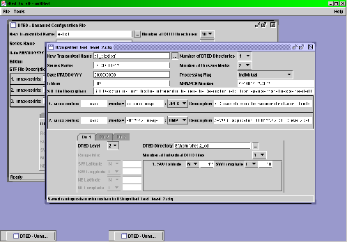 .
DTED to STF's Main Window
.
DTED to STF's Main Window
.
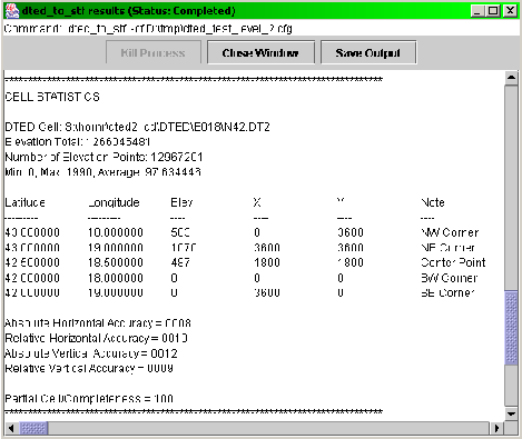 .
DTED to STF's Processing
Status Window
.
DTED to STF's Processing
Status Window
LIMITATIONS
- The current maximum number of different source data
paths is limited to 10.
- No support for <Hierarchy Summary>s.
- It doesn't publish anything for use with ITR.
- Mixed case file / directory names are not supported
on Unix platforms.
SYSTEM REQUIREMENTS
Hardware
- Recommended minimum CPU speed for Intel based machines
is 200 MHz.
- Recommended minimum RAM for all supported platforms
is 32 MB.
- Minimum disk space required is 10 MB. When converting
data, it is recommended to have at least as much free disk space available
as the size of the data to be converted.
Software
- Operating Systems Supported:
- SunOS 5.6 and 5.7
- Microsoft Windows 98/ME/NT/2000/XP
- SGI Irix64 6.5
- Linux (2.4.20-8 kernel) with glibc(2.3.2)
- Mac OS X (upon request)
- Software Requirements:
- Java JRE version 1.4 or better (needed for GUI)
POINT OF CONTACT
Send email to help@sedris.org for questions
or assistance in using this application.
As a minimum, please provide the following in your
email:
- application name
- application version
- hardware architecture
- OS name and version
- detailed problem description
PLANNED IMPROVEMENTS
- Currently looking into adding new data formats (for
example GeoTIFF).
- Working on adding a DTED directory / file layout
validator, to help users with non-standard DTED directory / file layouts.
The validator will assist the user to fix the non-standard layout for use
with this application as per the NGA DTED specification.
- Enhancing GUI use and help documentation.
- Support for automatic creation of resolution file
for <Browse Media> objects that have been added to the transmittal.
DOWNLOAD
- MacOS X version
- available on
request
.
|
Last updated:_December
7, 2004
|